

Johannesweg (St. John's pilgrimage route)


- Suitable for families
- culturally interesting
- Multi-day tour
- Flatly
- Possible accommodation
Interactive elevation profile
Create PDF
Tour-Details
Paths covering:
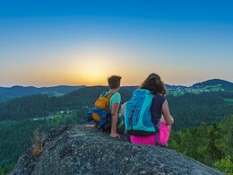
The healing power of nature is guaranteed to refresh you and restore your energy. As you follow the trail through the glorious Lower Mühlviertel countryside, you’ll find the confidence and energy you need to confront the challenges of everyday life.
The Johannesweg is 84 km long, so it provides ample time to reflect on what really matters, get a new perspective on things and recharge your batteries.
At 12 points along the trail you can find words of wisdom and inspiration designed to get you thinking.
With the hassle of everyday life left behind, you’ll find yourself looking at things with new eyes.
Discover the region in all its glory and walk at one with nature.
It was Dr Johannes Neuhofer who initiated the Johannesweg, and most walkers are happy to take on board his basic philosophy: let’s quit the rat race, get out into nature and simply switch off. His aim is to invite walkers on a journey of reflection.
Walking distance: approximately 84 kilometres
Walking time: three, four or five one-day stages
Height in metres: 3,000.
The landscape is fairly demanding, since it involves plenty of uphill and downhill stretches. We recommend that you assess your level of fitness carefully before setting out on the Johannesweg Trail.
The recommended starting point for the Johannesweg pilgrimage is the municipality of Pierbach. But you can begin walking from any of the places along the trail. A few metres past the village sign on the western edge of Pierbach we fork right, head up the Ramlberg and onward to the Irxenmayr family farm. Here you will find the Johannesbrunnen (St John's well) and the Engelskapelle (Chapel of the Angels, which are inviting places to stop and rest. If you like, you can visit the Irxwasser bottling plant and the ball mill and refill your water bottle.
We then follow the Little Naarn River downward for a while in the direction of Schönau. Upon leaving Schönau, we head up to the Herrgottsitz. The climb up to this rock, with its newly erected summit cross, is not particularly strenuous. Legend has it that after God had finished creating the world, he rested contentedly in the seat-shaped hollow of this rock formation. However, it’s more likely that the rock was used as a pagan sacrificial altar.
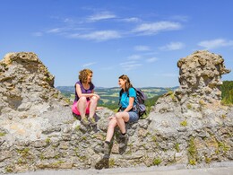
The trail now takes us onward to the Prandegg Castle ruin and the Zehentstöckl Castle Museum. From its distinctive round tower there is a glorious panoramic view all the way to the Alps.
We follow the path down into the valley of the Waldaist, where the water typically contains a high level of iron, then onward to the Herzogreither Rock, which is visible from some way off. You can still see the remains of abutments for posts and palisades at the top of a former wooden castle. Here too, a number of sacrificial bowls appear to suggest cultic activities in ancient times.
The Johannesweg Trail now leads us onward to St Leonhard bei Freistadt. A visit to the Wallfahrtskirche (or pilgrimage church), which dates from as far back as the beginning of the 12th century, is a fitting stop on our pilgrimage. The Bründlkapelle in the centre of the village is always worth looking out for. This chapel was built in 1728 on the ancient track that led from St Leonhard to Ennsedt. According to locals, the Bründl spring-water has significant healing powers, particularly for the eyes and ears.
Next we head uphill over the Haiderberg to Langfirling and Waldfeld, where we soon reach the Galgenbühel hill. In 1570, Sir Christian Haim, the Lord of Reichenstein, erected a set of gallows (still visible today through the trees) on land which was part of the Robischhof farm. This was intended as a deterrent and a show of strength, after his subjects revolted on account of the high level of vassalage and other levies imposed.
The trail now takes us downhill, through the forest and along a major road until we come to the Zwischenstromwiese meadow, the confluence of the two rivers, the Black Aist and the White Aist.
We follow the White Aist into the centre of the village of Weitersfelden.
Along meadow and forest paths and past an open-air cinema, we leave the houses behind, eventually reaching the Kammerer Cross. Take time to appreciate the magnificent view all the way to the Alps. You can spend a few quiet moments in the chapel there before setting out along the traiĺ towards Kaltenberg.
However, before we arrive in Kaltenberg, (the Mühlviertel’s second largest place of pilgrimage dedicated to the Virgin Mary), the path takes us past the original chapel and the Augenbründl. The Augenbründl, located roughly 150 metres north of the original chapel, was revered as a healing spring as far back as 1600, and was frequented chiefly by those with eye diseases.
We now return to the trail and head for Unterweißenbach. We pass 14(!) chapels built in exposed stone, a style typical of the region, gaining 200 metres in altitude. The roofs of the chapels are surmounted with the papal cross, while the facades are adorned with wooden reliefs of the stonemason Felix Weiß of Liebenau. This part of the path takes the form of a set of “Stations of the Cross”, where the eighth station is nicknamed the “Schüsselkapelle” after the water basin (or Schüssel) with its stone surround.
At length we reach Unterweißenbach with its parish church dedicated to St Nicholas. Culture aficionados should note its fine ribbed vaulting.
Next we clamber up to the Wegererstein. Our reward for the arduous climb to the highest point of Unterweißenbach is the lovely view down over the market, and beyond to Kaltenberg.
The trail takes us next to the Einsiedlerklause, where Sister Leonilla Wahlmüller, a Hermit of the Holy Cross known for her warm-hearted generosity, used to provide groups of pilgrims with advice and comfort. The whole hill is considered to be a place of power with special energies.
We now follow a forest track up to a natural platform surmounted by the Harlingsedt Summit Cross. Here we enjoy another glorious view over the rolling countryside of the Mühlviertel Alm, before descending the path to Königswiesen. On arrival in the market in Königswiesen it is worth taking a look in the church, with its unique loop rib vaulting. Then we benefit from a trek through the spectacular natural countryside to the village of Mötlas, where there is a lovely exposed stone chapel. We go on around the Bischofsberg and then uphill to the Ruttenstein ruin.
Once upon a time this castle was enormous and had seven circular towers. It dates back to the 12th century, is considered one of the most impressive ruins in the country and has been shown to be the largest fortification in Austria. At the Friedensfelsen (or Rock of Peace), situated above Pierbach, the “Finis Terrae”, the endpoint of the trail, gives us an opportunity for retrospection and reflection: “Look back at what you have experienced and take what you have learned home with you.”
Individual route planning
Depending on the time you have available and your level of fitness, you can visit www.johannesweg.at to choose between several different suggestions for your trip. The classic start point is Pierbach. However, you can of course set out from any location along the Johannesweg Trail. Normally you should allow 3 or 4 days for your pilgrimage. There is an accommodation list on the home page to help you find places to stay.
True to our motto, “Walk the path”, the Tourist Information Team for the Mühlviertler Alm at Freistadt will be happy to put together a personalised hike to suit your individual wants and needs.
further information:
- Multi-day tour
- Flatly
- Possible accommodation
- Experience of nature
Details - hiking
- themed path
")
")
")
")
")
")
")
")
")
")
")
")
")
Information about getting there using public transport
- Suitable for groups
- Suitable for seniors
- Suitable for single travelers
- Suitable for friends
- Suitable for couples
- Spring
- Summer
- Autumn
Please get in touch for more information.
")
Markt 19
4273 Unterweißenbach
Phone +43 50 7263 - 31
E-Mail anfrage@muehlviertel.at
Web www.johannesweg.at
Web www.muehlviertel-urlaub.at/
https://www.muehlviertel-urlaub.at/
You can also visit us on
Visit us on Facebook Visit us on Instagram")
")
")
")
")
")
")
")
")
")
")
")
")
")
")
")
")
")
")
")
")
")
")
")
")
")
")
")
")
")
")
")
")
")
")
")
")
")
")
")
")
")
")
")
")

")


")


")

")


")

")
")
")


")

")


")
")
")
")
")
")
")
")
")
")

")

")
")
")
")
")
")
Vis-à-vis users
1. The tours presented for hiking, walking, biking and road biking, mountain biking, motorbiking, horseback riding, climbing, cross-country skiing, and going on skiing and snowshoe tours etc. are to be considered non-paid tour recommendations and only serve as non-binding information. We have no intention of concluding a contract with the users of this website. The utilisation of the data does not lead to the establishment of a contract with us.
The data may only be used for private use; any commercial use is prohibited. In particular, it is not permissible to offer the data on commercially run websites, file-sharing platforms etc. or to use it to develop commercial products. Downloading data does not imply that users are granted rights to the data concerned.
The tour recommendations posted were created with utmost care; nevertheless, we assume no liability for the correctness and completeness of the information.
We point out that neither the tour recommendations included on this website nor the associated data and information were posted by us, but rather by third parties (Art. 16 Austrian E-Commerce Act). We have no influence on whether the details provided (e.g. distance, level of difficulty, change in altitude, description etc.) are authentic, correct and complete. We do not review these third-party contents. For this reason, we assume no liability for the authenticity, correctness and completeness of the information.
Construction-related measures or other influences (e.g. landslides and similar occurrences) can lead to temporary or permanent changes in a route (e.g. loss of a bridge and similar occurrences). Such occurrences can lead to part of the route or the entire route becoming impassable.
The use of the data as well as undertaking (riding, walking, taking etc.) the recommended tours or using the network of paths occurs at users’ own risk and on their authority. In particular, users themselves are responsible for the choice of route, outdoor orientation, adherence to traffic rules, supplies and equipment for tours listed in Point 1 (e.g. bicycle etc.), wearing a helmet, estimating their own fitness, recognising dangers and maintaining an appropriate velocity. We exclude ourselves from any liability whatsoever for damages, in particular accidents, that occur whilst taking part in the recommended tours.
2.Some of the tours lead over roads with normal traffic conditions. Please observe that there is an increased risk which can be avoided by means of appropriate attention and proper estimation and implementation of one’s own abilities. For this reason, please travel a route that is unfamiliar to you slowly and with special care. Pay constant attention to potential dangers and always observe traffic. Do not leave the routes featured in descriptions.
The potential use of private roads, in particular forestry roads and agricultural transport roads, can be subject to legal restrictions, which must be observed and adhered to.
The normal traffic rules apply. Each user (e.g. biker, motorbiker) is responsible for adhering to these rules and maintaining his/her bike/vehicle and its equipment (lights, brakes etc.) in good working order. Each user is also responsible for ensuring that he/she rides at a velocity that is appropriate for the conditions and his/her skill level and for maintaining sufficient distance to the rider in front. We explicitly recommend adjusting velocity to correspond to the respective field of vision, wearing a helmet, using reflective clothing (or similar) and employing bicycle lights in line with regulations.
3.Each tour requires good physical fitness as well as detailed planning. We explicitly recommend only taking the tours in the case of optimal healthiness.
We recommend that you conclude an accident and liability insurance policy. Use an onboard computer that displays the respective kilometres travelled per day and is calibrated for the front wheel.
4.Special for mountain bikers – Fair-play rules:
Mountain biking is one of the most wonderful outdoor leisure-time activities. Whilst biking or on a mountain biking tour, mountains and lakes, meadows and cabins are re-discovered in new ways. A couple of rules for fair play in the forest help to avoid conflicts whilst mountain biking.
a.Pedestrians have the right of way: We are accommodating and friendly to pedestrians and hikers. Upon encountering these fellow travellers, we alert them by using the bicycle bell and slowly overtake them. We avoid paths with heavy pedestrian traffic altogether. Take nature into account: We do not leave refuse behind.
b.The braking distance should be half of the total distance visible: We ride at a controlled pace, are ready to brake and maintain a braking distance half as long as the total distance visible, especially in curves, because we always have to count on obstacles on the path. Damage to the path, stones, branches, wood piles, grazing livestock, cattle grids, barriers, tractor-type forestry machines and authorised vehicles pose dangers that we need to be ready for.
c.Don’t drink and drive!: Do not drink alcohol when mountain biking. Take care at stop-off points (dealing with bike racks, dirty shoes or clothing).
It is obligatory to provide first aid!
d.Marked routes, closed paths and blockades: Keep to the marked routes, observe the blockades and accept that these roads are primarily for agricultural and forestry use!
Blockades can often not be avoided and are in your own interest. Biking beyond the intended path and outside of opening times is punishable and turns us into illegal bikers.
e.We are guests in the forest and behave accordingly, including vis-à-vis forestry and hunting staff. Whilst mountain biking, mobile telephones and music players are forbidden! Biking requires your full attention.
f.Avoid unnecessary noise. Out of consideration to the animals living in the wild, we only bike during full daylight. As a principle, we always wear our helmet (even when riding uphill)! Don’t forget emergency supplies: We always have a repair set and bandages along.
g.Don’t overestimate your skills: We should not overdo it when it comes to biking technique and physical fitness. Take the level of difficulty posed by the route into consideration and make a precise estimate of your experience and skills as a biker (braking, bell, lights)!
h.Close gates: We approach grazing livestock at a walking pace and close every gate behind us. We should avoid causing escape and panic reactions in the animals. Nothing stands in the way of the fun and athletic challenge in the mountains and forests!
i.Traffic rules: The general traffic rules (StVO) apply for all the mountain biking routes and we adhere to them. Our bike therefore needs to be in perfect technical condition and equipped in line with the traffic rules, including brakes, a bell and lights. We inspect and service our mountain bikes regularly anyway.
5.We assume no liability for the contents of external websites; in particular, we assume no liability for their statements and contents. Moreover, we have no influence on the design or contents of the websites to which hyperlinks on www.muehlviertel-almfreistadt.at lead or from which hyperlinks lead to www.muehlviertel-almfreistadt.at. There is no on-going review of websites to which hyperlinks on www.muehlviertel-almfreistadt.at lead or from which hyperlinks lead to www.muehlviertel-almfreistadt.at. We do not appropriate the contents of websites to which hyperlinks on www.muehlviertel-almfreistadt.at lead or from which hyperlinks lead to www.muehlviertel-almfreistadt.at.
Vis-à-vis bloggers
PLEASE OBSERVE:
1. Each of your tour recommendations for hiking, walking, biking and road biking, mountain biking, motorbiking, horseback riding, climbing, cross-country skiing, and going on skiing and snowshoe tours etc., along with other details and information, is free of charge. In particular regarding the correctness of the information, we assume no liability, nor do we assume any liability whatsoever for the consequences of the use of your tour recommendation by a third party (in particular by a user of this website). We do not review the tour recommendations you post, including other details and information, at any time.
We have no intention of concluding a contract with persons who post tour recommendations and/or other details and information on this website. Posting data (information) does not imply that a contract has been concluded.
By recommending a tour, we assume special responsibility vis-à-vis other athletes. Please take this responsibility seriously and describe your tour recommendation with utmost care and to the best of your knowledge and belief.
2.Your tour recommendations must therefore clearly and unambiguously include at least the following criteria and provide a sufficiently detailed description:
• Starting point
• Detailed route description
• Distance/Overall distance
• Level of difficulty
• Dangerous spots
• Average duration of trip
• Change in altitude
• Finishing point.
If possible, please provide the change in altitude.
3.When you post a tour recommendation, you give us the order to save your tour recommendation and/or the details you provide on our website and to make it/them accessible to third parties, in particular to users of this website, in the long term. We reserve the right to block or delete tour recommendations and/or other details and/or information that you post, either partially or entirely, at any time without providing a justification. Should this occur, it grants you no rights whatsoever.
Thank you for your efforts!
4. We are not responsible for the contents of external websites; in particular, we do not assume any liability for their statements or contents. Furthermore, we do not influence the design or contents of websites that can be accessed from www.muehlviertel-almfreistadt.at via hyperlinks or that use hyperlinks to refer to www.muehlviertel-almfreistadt.at. The websites that can be accessed from www.muehlviertel-almfreistadt.at via hyperlinks or that use hyperlinks to refer to www.muehlviertel-almfreistadt.at are not regularly monitored. Furthermore, we do not assume any claims to the websites that can be accessed from www.muehlviertel-almfreistadt.at via hyperlinks or that use hyperlinks to refer to www.muehlviertel-almfreistadt.at.
Interactive elevation profile
Create PDF
Tour-Details
Paths covering: