

Die Waldluftbade-Gesundheitstour


- All weather
- Suitable for families
- Flatly
Interactive elevation profile
Create PDF
Tour-Details
Paths covering:
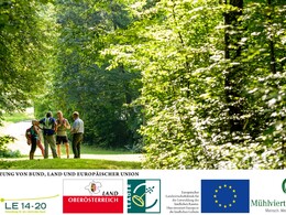
Feel - strengthen - be yourself - enjoy the Mühlviertel forest air bathing in the forests and places of strength. The forest air bathing health tour is a circular route covering around 170 kilometres through the Mühlviertler Alm Freistadt region from the Maltsch in the north to the confluence of the Feldaist and Waldaist rivers in the south. Along the way, there are 33 local forest air bathing trails in 12 certified forest air bathing communities. They lead through the enchanting landscapes of the Lower Mühlviertel.
The individual tours in the 12 certified forest air bathing communities can be found HERE.
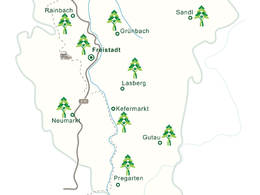
The large circular route of the Waldluftbaden health tour can be started in any of the 12 municipalities. The hub is the medieval brewing town of Freistadt. Here you will find three forest air bathing trails through the Bockau forest area to St.Peter, along the Feldaist river through the Thurytal valley and into the Zelletau forest area. And if you want to take in the beautiful "forest of houses" of the medieval old town, there is also a city tour available.
We follow the meditation trail to St.Peter and the health tour northwards into the Feldaisttal valley. We reach the horse-drawn railway town of Rainbach. From here, three forest trails branch off to the south through the wooded Jaunitztal valley, to the east through the Birau forest area to the Heidenstein in the village of Eibenstein and to the north. We make a detour to the Heidenstein and then follow the path northwards through the village of Kerschbaum and past the horse-drawn railway museum. We walk along the state border through the border forests of Leopoldschlag. In Wullowitz we find the Tobau moorland forest. Moorland forests have a very special effect on us, we should take a "forest nap" here. Shortly afterwards we reach the Maltsch. The woodland along the naturally flowing border river also has a very special effect on people and invites you to linger. Once we reach the market town of Leopoldschlag, two forest trails start here, leading eastwards to the border forests and southwards to the Leopoldschlägerberg, the Reisingerberg and to Hammern and Zettwing on the Maltsch. We follow this path and branch off at Reisingerberg to Windhaag bei Freistadt . In the village of the Green Belt Centre, two forest air bathing trails start to the east to the Reisingerberg and to the west over the Waschenberg into the Plochwald. We follow the latter on our health tour into the Freiwald forest. We hike over the Hundsberg at the foot of the Viehberg to Sandl and further south through Mitterbach and the Weinbergholz until we reach St. Michael. The little church in Rauchenödt is the strongest place of strength on the health tour. We reach Grünbach via the forests of the Heinrichschlägerberg. Three forest bathing trails lead through the municipality to St. Michael, to Lichtenau and to the Feldaist. We follow the latter through the Thurytal valley along the Feldaist back to Freistadt.
We now leave Freistadt to the east towards the Zelletau forest area and walk southwards through the forests of the Haugenödtberg and Koppenberg to Lasberg. Lasberg has three forest trails to the south-eastern hilltop area, to the northern wooded highlands and to the Dornach castle ruins in the west. The latter is a shortcut to the health tour to Kefermarkt. However, we follow the health tour over the Buchberg and the Braunberg through the charming hilltop country, which continues in the villages of Fürling and Erdmannsdorf in the municipality of Gutau. The blueprinting and dyeing community has three forest air bathing trails in the municipality. The path just walked into the northern hilltop country, through the ravine forests of the Waldaist to the ruins of Prandegg Castle and over the wooded heights of Hundsberg, Gutenbrunnerberg and Gaisruckberg to Reichenstein. From Gutau we hike through the Waldaist-Naarn European nature reserve to Reichenstein and from there to the village of Tragwein. This municipality has three forest bathing paths along the Kettenbach, to the Greisinghof with a detour to Reichenstein and to the southernmost point of the health tour to Hohensteg to the confluence of the Feldaist and Waldaist rivers to form the Aist. We follow this and enjoy the spectacle of the marriage of the two very different river personalities. We then head northwards again through the Feldaisttal nature reserve to Pregarten. In Pregarten, three forest trails lead to the southern and northern Feldaisttal valleys and through deep creek cuts and ravine forests to the ruins of Reichenstein Castle. We follow the Feldaist upstream to the north, past the Pienkenhof nature trail and along the wooded ridge of the village of Harterleiten to Kefermarkt. The market town with its famous Gothic winged altar and Weinberg Castle has three forest trails to the north to Buchberg, to Elz and back through the enchanting Flanitztal valley, to the east to Luchsberg and to the south to the Feldaist and the Pienkenhof nature trail. In Kefermarkt, we head west and cross the Kefermarkt basin to Neumarkt. The southern Waldluftbadeweg from Neumarkt leads through the picturesque Gusental valley, the western one through highlands and over wooded hilltops. We follow this to the Bloßsteinhöfe village of Stiftung, cross the upper Gusental valley and hike through the mountains via the Zeissberg to the Tröllsberg back to Freistadt.
further information:
- Flatly
Details - hiking
- themed path
")
")
")
")
")
")
")
")
")
")
")
")


- All weather
- Suitable for groups
- Suitable for seniors
- Suitable for single travelers
- Suitable for friends
- Suitable for couples
- Suitable for children
- Spring
- Summer
- Autumn
Please get in touch for more information.
")
Waaggasse 6
4240 Freistadt
Phone +43 5 07263 - 21
E-Mail anfrage@muehlviertel.at
Web www.waldluftbaden.at
Web www.muehlviertel-urlaub.at
https://www.muehlviertel-urlaub.at
")
")
")
")
")
")
")
")


")
")
")

")

")


")


")
")
")
")

")

")
")
")
")
")
")
")
")
")

Vis-à-vis users
1. The tours presented for hiking, walking, biking and road biking, mountain biking, motorbiking, horseback riding, climbing, cross-country skiing, and going on skiing and snowshoe tours etc. are to be considered non-paid tour recommendations and only serve as non-binding information. We have no intention of concluding a contract with the users of this website. The utilisation of the data does not lead to the establishment of a contract with us.
The data may only be used for private use; any commercial use is prohibited. In particular, it is not permissible to offer the data on commercially run websites, file-sharing platforms etc. or to use it to develop commercial products. Downloading data does not imply that users are granted rights to the data concerned.
The tour recommendations posted were created with utmost care; nevertheless, we assume no liability for the correctness and completeness of the information.
We point out that neither the tour recommendations included on this website nor the associated data and information were posted by us, but rather by third parties (Art. 16 Austrian E-Commerce Act). We have no influence on whether the details provided (e.g. distance, level of difficulty, change in altitude, description etc.) are authentic, correct and complete. We do not review these third-party contents. For this reason, we assume no liability for the authenticity, correctness and completeness of the information.
Construction-related measures or other influences (e.g. landslides and similar occurrences) can lead to temporary or permanent changes in a route (e.g. loss of a bridge and similar occurrences). Such occurrences can lead to part of the route or the entire route becoming impassable.
The use of the data as well as undertaking (riding, walking, taking etc.) the recommended tours or using the network of paths occurs at users’ own risk and on their authority. In particular, users themselves are responsible for the choice of route, outdoor orientation, adherence to traffic rules, supplies and equipment for tours listed in Point 1 (e.g. bicycle etc.), wearing a helmet, estimating their own fitness, recognising dangers and maintaining an appropriate velocity. We exclude ourselves from any liability whatsoever for damages, in particular accidents, that occur whilst taking part in the recommended tours.
2.Some of the tours lead over roads with normal traffic conditions. Please observe that there is an increased risk which can be avoided by means of appropriate attention and proper estimation and implementation of one’s own abilities. For this reason, please travel a route that is unfamiliar to you slowly and with special care. Pay constant attention to potential dangers and always observe traffic. Do not leave the routes featured in descriptions.
The potential use of private roads, in particular forestry roads and agricultural transport roads, can be subject to legal restrictions, which must be observed and adhered to.
The normal traffic rules apply. Each user (e.g. biker, motorbiker) is responsible for adhering to these rules and maintaining his/her bike/vehicle and its equipment (lights, brakes etc.) in good working order. Each user is also responsible for ensuring that he/she rides at a velocity that is appropriate for the conditions and his/her skill level and for maintaining sufficient distance to the rider in front. We explicitly recommend adjusting velocity to correspond to the respective field of vision, wearing a helmet, using reflective clothing (or similar) and employing bicycle lights in line with regulations.
3.Each tour requires good physical fitness as well as detailed planning. We explicitly recommend only taking the tours in the case of optimal healthiness.
We recommend that you conclude an accident and liability insurance policy. Use an onboard computer that displays the respective kilometres travelled per day and is calibrated for the front wheel.
4.Special for mountain bikers – Fair-play rules:
Mountain biking is one of the most wonderful outdoor leisure-time activities. Whilst biking or on a mountain biking tour, mountains and lakes, meadows and cabins are re-discovered in new ways. A couple of rules for fair play in the forest help to avoid conflicts whilst mountain biking.
a.Pedestrians have the right of way: We are accommodating and friendly to pedestrians and hikers. Upon encountering these fellow travellers, we alert them by using the bicycle bell and slowly overtake them. We avoid paths with heavy pedestrian traffic altogether. Take nature into account: We do not leave refuse behind.
b.The braking distance should be half of the total distance visible: We ride at a controlled pace, are ready to brake and maintain a braking distance half as long as the total distance visible, especially in curves, because we always have to count on obstacles on the path. Damage to the path, stones, branches, wood piles, grazing livestock, cattle grids, barriers, tractor-type forestry machines and authorised vehicles pose dangers that we need to be ready for.
c.Don’t drink and drive!: Do not drink alcohol when mountain biking. Take care at stop-off points (dealing with bike racks, dirty shoes or clothing).
It is obligatory to provide first aid!
d.Marked routes, closed paths and blockades: Keep to the marked routes, observe the blockades and accept that these roads are primarily for agricultural and forestry use!
Blockades can often not be avoided and are in your own interest. Biking beyond the intended path and outside of opening times is punishable and turns us into illegal bikers.
e.We are guests in the forest and behave accordingly, including vis-à-vis forestry and hunting staff. Whilst mountain biking, mobile telephones and music players are forbidden! Biking requires your full attention.
f.Avoid unnecessary noise. Out of consideration to the animals living in the wild, we only bike during full daylight. As a principle, we always wear our helmet (even when riding uphill)! Don’t forget emergency supplies: We always have a repair set and bandages along.
g.Don’t overestimate your skills: We should not overdo it when it comes to biking technique and physical fitness. Take the level of difficulty posed by the route into consideration and make a precise estimate of your experience and skills as a biker (braking, bell, lights)!
h.Close gates: We approach grazing livestock at a walking pace and close every gate behind us. We should avoid causing escape and panic reactions in the animals. Nothing stands in the way of the fun and athletic challenge in the mountains and forests!
i.Traffic rules: The general traffic rules (StVO) apply for all the mountain biking routes and we adhere to them. Our bike therefore needs to be in perfect technical condition and equipped in line with the traffic rules, including brakes, a bell and lights. We inspect and service our mountain bikes regularly anyway.
5.We assume no liability for the contents of external websites; in particular, we assume no liability for their statements and contents. Moreover, we have no influence on the design or contents of the websites to which hyperlinks on www.muehlviertel-almfreistadt.at lead or from which hyperlinks lead to www.muehlviertel-almfreistadt.at. There is no on-going review of websites to which hyperlinks on www.muehlviertel-almfreistadt.at lead or from which hyperlinks lead to www.muehlviertel-almfreistadt.at. We do not appropriate the contents of websites to which hyperlinks on www.muehlviertel-almfreistadt.at lead or from which hyperlinks lead to www.muehlviertel-almfreistadt.at.
Vis-à-vis bloggers
PLEASE OBSERVE:
1. Each of your tour recommendations for hiking, walking, biking and road biking, mountain biking, motorbiking, horseback riding, climbing, cross-country skiing, and going on skiing and snowshoe tours etc., along with other details and information, is free of charge. In particular regarding the correctness of the information, we assume no liability, nor do we assume any liability whatsoever for the consequences of the use of your tour recommendation by a third party (in particular by a user of this website). We do not review the tour recommendations you post, including other details and information, at any time.
We have no intention of concluding a contract with persons who post tour recommendations and/or other details and information on this website. Posting data (information) does not imply that a contract has been concluded.
By recommending a tour, we assume special responsibility vis-à-vis other athletes. Please take this responsibility seriously and describe your tour recommendation with utmost care and to the best of your knowledge and belief.
2.Your tour recommendations must therefore clearly and unambiguously include at least the following criteria and provide a sufficiently detailed description:
• Starting point
• Detailed route description
• Distance/Overall distance
• Level of difficulty
• Dangerous spots
• Average duration of trip
• Change in altitude
• Finishing point.
If possible, please provide the change in altitude.
3.When you post a tour recommendation, you give us the order to save your tour recommendation and/or the details you provide on our website and to make it/them accessible to third parties, in particular to users of this website, in the long term. We reserve the right to block or delete tour recommendations and/or other details and/or information that you post, either partially or entirely, at any time without providing a justification. Should this occur, it grants you no rights whatsoever.
Thank you for your efforts!
4. We are not responsible for the contents of external websites; in particular, we do not assume any liability for their statements or contents. Furthermore, we do not influence the design or contents of websites that can be accessed from www.muehlviertel-almfreistadt.at via hyperlinks or that use hyperlinks to refer to www.muehlviertel-almfreistadt.at. The websites that can be accessed from www.muehlviertel-almfreistadt.at via hyperlinks or that use hyperlinks to refer to www.muehlviertel-almfreistadt.at are not regularly monitored. Furthermore, we do not assume any claims to the websites that can be accessed from www.muehlviertel-almfreistadt.at via hyperlinks or that use hyperlinks to refer to www.muehlviertel-almfreistadt.at.
Interactive elevation profile
Create PDF
Tour-Details
Paths covering: